Hurricane Frances Updates September 1-5, 2004 Last update: 10:00 a.m. – 9/5
Please do NOT call WDW UNLESS
you have a scheduled arrival between now and Tuesday, 9/7.
The Walt Disney World Theme Parks, Water Parks, Recreation Areas, the Boardwalk and all areas of Downtown Disney will not operate on Saturday, September 4 based upon forecasts from the National Weather Service and information from emergency preparedness officials.
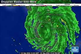
Photo from Weather.com 12:24pm
![]() "Live" Reports from WDW & Orlando
"Live" Reports from WDW & Orlando
Live Reports from Vero Beach
Orlando Area Updates
Orlando International & Florida Airport Updates
Disney Cruise Line and Port Canaveral
![]() Weather Updates
Weather Updates
WDW Closings and Updates
Related Links
Airline and Expedia Updates
A VERY Special Thanks
to everyone who sends updates to help us keep folks informed!
Send to: [email protected]
**********
![]() Sunday, 9/5/04, 8:00am – OrlandoWeather.com – CONDITIONS EXPECTED TO WORSEN IN ORANGE COUNTY Orange County can still expect increasing winds over the next several hours. At a noon briefing, Orange County Chairman Rich Crotty said the major issues facing the county is power outages and flooding. So far, 88,000 residents are without electricity.
Sunday, 9/5/04, 8:00am – OrlandoWeather.com – CONDITIONS EXPECTED TO WORSEN IN ORANGE COUNTY Orange County can still expect increasing winds over the next several hours. At a noon briefing, Orange County Chairman Rich Crotty said the major issues facing the county is power outages and flooding. So far, 88,000 residents are without electricity.
Crotty warned residents to resist the urge to go outside, and drivers should stay off area roadways. The increasing winds are resulting in more debris on the roads and highways, as well as damaged or inoperable traffic signals. Drivers should treat those intersections as four-way stops.
Despite the damage, Crotty said he hoped to have Orange County operating again by Tuesday.
Frances Maintains 90 MPH Winds
Hurricane Frances is centered over Okeechobee County and forecasters said the worst conditions from the storm should arrive in Central Florida's metro areas in about 2 hours.
Some strong storms are moving into southern Brevard County, and Volusia County has been pounded with whipping winds and heavy rain.
Most Central Florida counties have reported receiving about 1 or 2 inches of rain so far, but some parts of Brevard County have seen as much as 10 inches.
In about 4 hours, Frances should be near Winter Garden and on its way toward Tampa. Most of the Central Florida region will feel tropical storm-force winds all day Sunday.
Millions Without Power
Hurricane Frances is just starting to make her presence felt in Central Florida, but already, millions of residents have lost their power.
It's now a Category 1 hurricane with top sustained winds of 90 mph. Forecasters said some areas have yet to feel the worst the storm has to offer, and even as Frances weakens, forecasters said it could regain intensity when the storm tracks back over the warm water of the northeastern Gulf of Mexico.
Wind and rain have snapped trees and ripped apart roofs. Officials said the biggest danger is from water — storm surges and torrential rains. Some evacuees had to move a second time when the roof at a school being used as a shelter was partially blown off.
At a morning press conference, Gov. Jeb Bush urged residents to remain in their homes while the storm makes its way across the peninsula.
Florida Power and Light said 4 million people up and down the state have been touched by outages during Hurricane Frances. Power is back on for 1 million people, but crews are just starting to roll to help the other 3 million.
Palm Beach County by far is in the worst shape with outages affecting 1.3 million people. Broward is around 1 million, and Miami-Dade around 650,000.
Progress Energy reports 238,112 of its customers are without power, including 2,418 in Lake County, 12,631 in Marion County, 87,939 in Orange County, 1,802 in Osceola County, 2,700 in Polk County, 46,503 in Seminole County, and 48,185 in Volusia County. Orlando Utilities Commission reports 32,500 customers are in the dark, including 27,000 in Orange County and 5,500 in Osceola County. More than 1.5 million Florida Power and Light customers are without power, including 144,000 in Brevard County, 5,200 in Seminole County, and 29,000 in Volusia County.
Kissimmee Utility Authority, which was hit particularly hard during Hurricane Charley three weeks ago, reports 13,900 of its customers have lost power.
Sunday, 9/5/04, 8:00am – OrlandoWeather.com – Hurricane Frances is just starting to make her presence felt in Central Florida, but already, millions of residents have lost their power. It's now a Category 1 hurricane with top sustained winds of 95 mph. Forecasters said some areas have yet to feel the worst the storm has to offer, and even as Frances weakens, forecasters said it could regain intensity when the storm tracks back over the warm water of the northeastern Gulf of Mexico.
Wind and rain have snapped trees and ripped apart roofs. Officials said the biggest danger is from water — storm surges and torrential rains. Some evacuees had to move a second time when the roof at a school being used as a shelter was partially blown off.
Progress Energy reports 75,000 of its customers are without power, including 1,800 in Marion County, 34,000 in Orange County, 2,700 in Polk County, 9,300 in Seminole County, and 12,400 in Volusia County. Orlando Utilities Commission reports 32,500 customers are in the dark, including 27,000 in Orange County and 5,500 in Osceola County. More than 1.5 million Florida Power and Light customers are without power, including 144,000 in Brevard County, 5,200 in Seminole County, and 29,000 in Volusia County.
Kissimmee Utility Authority, which was hit particularly hard during Hurricane Charley three weeks ago, reports 6,600 of its customers have lost power.
The utility companies warned that many more residents are likely to lose power as Hurricane Frances moves through Central Florida.
Sunday, 9/5/04, 1:00am – OrlandoWeather.com CENTRAL FLORIDA POUNDED BY WINDS AND RAINS
7 Counties Under Flood Warning. The winds are picking up, and Hurricane Frances is dumping heavy amounts of rain on Central Florida. Radar estimates indicated that the outer bands of the hurricane have already dumped two to three inches of rain in eastern Central Florida, with some areas receiving up to five inches so far. Early Sunday morning, wind gusts measured 46 mph at Walt Disney World, 53 mph in Daytona Beach and 83 mph in Okeechobee County, just south of Osecola County. The wet and windy weather is likely to get uglier as the day goes on. Several more inches of rain are expected to fall as Hurricane Frances drifts slowly across the state. The National Weather Service said the flooding will become more extensive and significant overnight and through the daytime hours Sunday.
Hurricane Frances has made landfall in Martin County. The western edge of the eyewall came ashore near Hobe Sound just before 10 p.m. Saturday, and over the next several hours, the eye slowly moved inland. A hurricane warning remains in effect from Florida City northward to Flagler Beach including Lake Okeechobee. The center of the hurricane's eye made landfall at about 1 a.m. near Sewall's Point, just east of Stuart. At 1 a.m., Frances was centered at latitude 27.2 north, longitude 80.2 west.
Frances picked up some speed early Sunday morning, moving toward the west-northwestward near 7 mph. At this pace, the entire eye is expected to move inland by sunrise Sunday. The western portion of the eyewall has already moved inland over portions of Palm Beach, Martin and St. Lucie Counties. Top winds of 105 mph may bring up to 20 inches of rain and heavy flooding. Hurricane-force winds extend outward from the center 85 miles and tropical storm winds extend outward up to 200 miles. There is still a chance the storm will strengthen slightly before the eastern part of the eye moves inland. Transformers popped along streets, sending sparks into darkened skies, as families huddled in shelters, bathrooms and hotel lobbies. The wind-whipped coastal waters resembled a churning hot tub.
Saturday 9/4/04 4 p.m OrlandoWeather.com FRANCES STALLS; EVACUEES PACK SHELTERS About 54,000 people are waiting for the arrival of Hurricane Frances in storm shelters across Florida. Half the room watched a college football game. The other half stared into small black-and-white TVs showing the latest news about Hurricane Frances. In the middle of it all at a Port Salerno shelter, one man snored away.
Blankets, sleeping bags and couch cushions covered nearly the entire floor. Bags of food and bottles of water were stacked in every direction. The men moved in two directions — toward the door to sneak a quick cigarette or toward the bathroom.
More than 14-hundred people are crammed into the classrooms at Pinewood Elementary School. Evacuation requests cover about 2.8 million people — the biggest in state history. Tens of thousands of residents across Florida are already in the dark as Hurricane Frances lashes the coastline.
Saturday 9/4/04 1 p.m OrlandoWeather.com The outer bands of Hurricane Frances are bringing rain to an already saturated Central Florida. Five counties — Lake, Polk, Seminole, Sumter and Volusia — are under a flood warning. The National Weather Service in Melbourne said moderate flooding is expected for the St. Johns River near Lake Harney, with the potential for major flooding. Towns near the river, such as Sanford and DeLand, should also expect flooding over the next five days.
A flood warning has been issued for several rivers in Polk and Sumter Counties.The coast of Central Florida is beginning to feel the force of a strengthening Hurricane Frances as trees fall and residents lose power.
Officials across Central Florida are enacting mandatory curfews until Hurricane Frances has passed. Residents are asked to stay inside during the hurricane and leave roadways cleared for use by emergency vehicles. Citizens are also being asked to limit 911 calls, as well.
"The time has come for citizens to be in a safe location and off our streets," Orange County Chairman Rich Crotty said.
The first band from Frances hit Orange County just after 11 a.m. in east Orange County. Ponding of water is already being reported on local roadways, and current estimates for total rainfall from the storm are in the range of 12 inches.
In Osceola County, the first heavy rain band damaged a power feeder line along U.S. Highway 192 and Neptune Road. A portion of a motel sign blew into the line, but utility crews were able to restore service. Sporadic power outages are being reported by the Kissimmee Utility Authority.
Florida Power and Light officials said they're getting reports of outages north of Palm Beach into Melbourne.
Drivers should remember that intersections without power should be treated as four-way stops. Vehicles should remain off the roadways through Sunday, officials said.
Saturday 9/4/04 11 a.m OrlandoWeather.com Frances Drifts West-Northwest, Packs 105 MPH Winds
Hurricane Warning Issued For Central Florida. A hurricane warning is in effect from Florida City northward to Flagler Beach including Lake Okeechobee. At 11 a.m., Frances was about 80 miles east of West Palm Beach centered at latitude 26.9 north, longitude 78.8 west. Forecasters said the storm has developed a large eye about 70 miles wide, and satellite imagery suggests a more organized cloud pattern, as well. Top winds of 105 mph may bring up to 20 inches of rain and heavy flooding. Hurricane-force winds are about 105 miles wide.
Friday 9/3/04 8 p.m OrlandoWeather.com — Hurricane Frances weakened to a still-strong Category 2 hurricane Friday night, and she continued to drift slowly toward the Florida coast. The outer squalls of Hurricane Frances began moving over Florida Friday, and forecasters said weather should begin to deteriorate gradually. Frances is expected to hit somewhere in Florida Saturday afternoon or evening. The center of Hurricane Frances is located near latitude 25.9 north, longitude 77.5 west, or about 200 miles east-southeast of Florida's lower east coast. Frances is moving toward the west-northwest near 4 mph. Top sustained winds are 105 mph, with higher gusts. Some fluctuations in intensity are forecast during the next 24 hours. Although Frances weakened slightly, she still has the potential to push ashore waves up to 14 feet high. With its imposing size and slow movement, Frances could ravage the state. Forecasters said the slower the storm moves across the ocean, the longer its winds and rain could linger. They warn Frances could bring 10 to 20 inches of rain.
Thursday 9/2/04 7 p.m. – Local News 6 Reports: The Tropical Prediction Center's projected path for Hurricane Frances has the storm making landfall just north of Vero Beach, Fla., with 135 mph winds. The updated storm course shows Frances losing some of its punch as it hits land and moves through the state Saturday. It can make landfall any time from noon to 2 p.m., according to Thursday night's model. The storm is then expected to move south of Orlando and then pass over Osceola County, Fla. It then should move through Brooksville, Fla., and into the Gulf of Mexico.
Thursday 9/2/04 – Gov. Bush urged those who were considering visiting the state for the holiday to consider what's best for their personal and family's safety. "If you decide to spend Labor Day weekend somewhere else, we ask that you reschedule your trip and not cancel it. Florida will always be a hospitable place and we want our visitors to come back with great regularity," Bush said.
**********
![]() SATURDAY, SEPTEMBER 4th – Hess Gas Stations on WDW property are now CLOSED
SATURDAY, SEPTEMBER 4th – Hess Gas Stations on WDW property are now CLOSED
![]() SATURDAY, SEPTEMBER 4th – The Walt Disney World Theme Parks, Water Parks, Recreation Areas, the Boardwalk and all areas of Downtown Disney will not operate on Saturday, September 4 based upon forecasts from the National Weather Service and information from emergency preparedness officials.
SATURDAY, SEPTEMBER 4th – The Walt Disney World Theme Parks, Water Parks, Recreation Areas, the Boardwalk and all areas of Downtown Disney will not operate on Saturday, September 4 based upon forecasts from the National Weather Service and information from emergency preparedness officials.
Select dining locations will be available at WDW resorts for a period of time prior to the storm for resort guests only, with the exception of Disney's Spirit of Aloha Dinner Show and the Hoop-Dee-Doo Musical Revue which have been cancelled. For guests with priority seating for Character Dining in a resort location, meal service will be provided, but characters will not appear.
We anticipate resuming limited operations sometime on Sunday, September 5 after the storm has passed.
LETTER TO WDW RESORT GUESTS 9/3/04
Guests Advised to Prepare with meals
Based on current estimates of the length of time for the storm to clear the area, we have advised guests that they may need be in their room for up to 30 hours. With that in mind, they should consider any personal items or toiletries that they may need as we will not be able to provide housekeeping services during the storm. We strongly advise guests to visit the merchandise location, Food Court or quick service dining locations in their resort to obtain non-perishable food items that can be taken to their room. Guests should consider completing preparations as soon as possible to avoid long waits in these locations.
Advisory for during the storm
In view of the size, strength, and possible path of this hurricane, we have requested that guests remain in their Guest room for their safety and do the following:
Keep away from windows and stay on the far side of the room.
Keep connecting room doors open during periods when privacy is not necessary.
So that we may reach Guests in the event of an emergency, do not double lock Guest room doors.
Leave Guest room blinds or drapes closed and all patio furniture in the room.
If your resort loses power, remain in the room.
After the storm has passed, it will be critical that Guests remain in their room until they have been notified that it is safe. Even if severe weather conditions have subsided, it could only be a break in storm activity. Additionally, crews will need to complete an evaluation of the area to ensure the safety of our Cast and Guests.
Special Programming
In addition to regular programming on in-room television, we will present the following Disney animated feature films on these channels:
Finding Nemo — Channel 14
Monsters, Inc. — Channel 18
Brother Bear — Channel 23News and forecasts regarding Hurricane Charley can be found on local network affiliates.
After the storm
We will complete assessments of the area and initiate recovery as soon as conditions allow. We will provide updates on the operating schedule on Channel 19 of the in-room television as soon as they are available.
*****
FRIDAY, SEPTEMBER 3rd
Cirque du Soleil shows for Saturday, 9/4 have been cancelled.
It is reported that Downtown Disney will remain open until Midnight Friday, 9/3
Jellyrolls & Atlantic Dance are closed until operations return to normal. ESPN is open today, 9/3.
WDW Palm, Magnolia, Oak Trail and Lake Buena Vista Golf Courses are closed September 3. This includes the cancellation of all lessons, and the closing of all pro shops and food and beverage locations at the courses. Guests with tee times are being notified.
NOTE: Eagle Pines and Osprey Ridge are open September 3.
ALL WDW golf courses will be closed Saturday and Sunday, September 4-5.Osprey Ridge is scheduled to reopen Monday, September 6, however that will be re-evaluated once the storm has passed. If another course is in playing condition, WDW will make every effort to open that course.
Walt Disney World – Due to the impending threat from Hurricane Frances, the Walt Disney World Resort has adjusted the following operating hours for September 3, 2004:
Magic Kingdom — 9am – 8pm; Share a Dream Come True parade – 3pm; Wishes – 8pmEpcot – Future World — 9am – 7pm; World Showcase — 11am – 9pm; Illuminations — 9pmDisney-MGM Studios — 9am – 6pm; Disney Stars & Motorcars Parade — 3:30pm; Fantasmic! — cancelledAnimal Kingdom — 9am – 5pm; Mickey's Jammin' Jungle parade – 4pm;
Blizzard Beach — 10am – 6pmTyphoon Lagoon — 10am – 6pmDowntown Disney
Marketplace — Shops open until 6pm; Dining open until 9pmPleasure Island — Not OperatingWest Side Shops — Shops open until 6pm; Dining open until 9pmDisneyQuest — 11:30am – 6pmCirque du Soleil — performing 6pm show only; 9pm show cancelledMiniature Golf (Fantasia Gardens & Winter Summerland) — 10am – 6pm
Disney's Spirit of Aloha Dinner Show — No Shows on 9/3 & 9/4
Hoop-Dee-Doo Musical Revue 9:30pm show cancelled on 9/3 No Shows on 9/4Electrical Water Pageant — Cancelled
All Walt Disney World Resort hotels will remain open throughout the storm. Guests staying at Disney's Fort Wilderness Resort & Campground will be relocated to other hotels on property.
Priority Seatings – Priority seatings for any resort dining location will not be taken for the period of dinner Friday 9/3 through dinner Sunday 9/5. No theme park bookings for meals are being accepted for Saturday 9/4 and Sunday 9/5. If you have a Priority Seating and need to cancel, call 407-WDW-DINE (any applicable cancellation fees will be waived if you cancel). (Posted 9/2/04)
Hoop-De-Doo Revue Ft. Wilderness – Friday 9/4 9:30 show is cancelled; 5:00 and 7:15 still on at this time. All shows cancelled for Saturday September 4. (9am; 9/2/04)
Spirt of Aloha Show at the Polynesian – all shows cancelled for Friday 9/3 and Saturday 9/4 (9am; 9/2/04)
The Vero Beach DVC Resort closed at noon on 9/2/04 until further notice. Guests with future arrival dates are being advised. (9am; 9/2/04)
Tom Joyner Family Reunion schedule for this weekend is CANCELLED (9am; 9/2/04)
Fantasmic! shows are cancelled September 3 – 6.
A temporary cancellation/rebooking policy is now in effect for WDW from September 1 – 6, 2004. During this time, you may cancel or change your reservation without penalty. If you booked your stay with someone other than a Travel Agent or WDW directly, you will need to contact that seller. Guests who have questions should call (407) WDW-INFO; (407) 939-4636. (5:00pm, 9/1/04)
**********
Orlando International Airport Updates
![]() Saturday 10:30pm Tampa Airport: As of 10:30pm Saturday night all flights out of Tampa International Airport are cancelled until further notice. People are still encouraged to call and check on flights depending on the airlines. Jessica Smolinski
Saturday 10:30pm Tampa Airport: As of 10:30pm Saturday night all flights out of Tampa International Airport are cancelled until further notice. People are still encouraged to call and check on flights depending on the airlines. Jessica Smolinski
Saturday, 9/4; noon: Orlando International Airport is closed, and a spokeswoman said they probably will not resume operations until at least Monday. http://www.orlandoairports.net:/goaa/press/20040903_1309.htm By Friday evening, the runways were cleared of planes and most passengers had left the terminals. Commercial flights ceased at 12 p.m. Friday, even though Orlando was still enjoying Frances-free weather.
Rosie writes: Jacksonville airport is open today and says some flights still have openings. But they have been running the bottom the TV screen that Delta has canceled flights on Sat. And others may also, so it may not be open Sat. (3:30pm 9/3/04)
Orlando International Airport (MCO) Commercial passenger flight operations have ceased at Orlando International Airport. Airport personnel continue to monitor weather conditions. Final preparations are under way in anticipation of inclement weather associated with Hurricane Frances. Normal flight operations will resume when weather permits and clean up operations are completed. Once flights resume, passengers wishing to confirm flight information will need to contact their particular air carrier prior to coming to the airport. Orlando International Airport is not an emergency shelter. 1:00pm 9/3/04
Orlando International Airport (MCO) and Orlando Executive Airport (ORL) will close at NOON Friday, September 3 due to the Hurricane. Domestic passengers holding reservations for flights prior to noon on Friday, September 3, 2004, need to arrive 3 hours prior to their departure. For further information on flight schedules up that time, please contact the airline directly. The Hyatt Hotel at Orlando International Airport is booked and sold out. Normal flight operations will resume when weather permits and clean up operations are completed. Orlando International Airport is not an emergency shelter.
For information on all arrivals/departures for Orlando International Airport (MCO), visit:
http://www.orlandoairports.net/goaa/fids/fidsform.htm
**********
![]() Orange County, a curfew will be in effect from 9 p.m. until 6 a.m. Saturday and Sunday nights.
Orange County, a curfew will be in effect from 9 p.m. until 6 a.m. Saturday and Sunday nights.
Universal, IoA, and CityWalk have decided to stay open until 6:00 PM Friday, 9/3/04
SeaWorld, Discovery Cove, will close at 3 p.m. on Friday and will remain closed on Saturday. http://www.wftv.com/
Orange County Schools are closed Friday Sept. 3. Also, all county school extracurricular activiites have been canceled Friday through the weekend. (5 p.m., 9/1/04)
STATEWIDE: Gov. Jeb Bush declared a state of emergency throughout Florida because of the hurricane, activating the National Guard. The state's Emergency Operations Center was open.
AMTRAK: Southbound Amtrak trains scheduled to end in Miami will instead terminate in Jacksonville on Thursday and Friday. Northbound service from Florida was not expected to be affected Thursday.
NASA: The Kennedy Space Center planned to close on Thursday and Friday to allow workers time to board up their homes and evacuate, if necessary, NASA officials said.
![]() Craig, Orlando, 10am Sunday 9/5: The winds are strong enough that it’s scary. But not raining too much yet. I hate to think both are getting worse. We took one power hit shortly after 9 AM, but it came right back on.
Craig, Orlando, 10am Sunday 9/5: The winds are strong enough that it’s scary. But not raining too much yet. I hate to think both are getting worse. We took one power hit shortly after 9 AM, but it came right back on.
Craig, Orlando, 8am Sunday 9/5: The weather continues to be wind and rain, with short moments of quiet. We’ve had 3 inches of rain in the last 12 hours. We don’t expect to see the worst of it for another four to six hours. The projected path show Orlando and Walt Disney World are in areas that expect sustained winds of tropical storm strength (under 74 MPH) rather than hurricane strength.
Tom Balint, Jr. Home in New Jersey – 8am Sunday 9/5:
Safe and sound back in New Jersey. First and foremost, my thoughts and prayers to those in Florida. From what the airline personnel were saying, our 2:45 flight out was one of the last from Tampa. They were not allowing any more inbound flights to land and were getting as many out as they could. As I was wandering about the world this past week, I could see the effects of Charlie clearly evident through out the parks and resorts. There were trees down on the old disney institiute villas, uprooted trees and cut off stumps throughout (although you did need to look to see many, they did a good job cleaning up).
There were also many signs broken, etc. in the surrounding area. Comparing Charlie and Frances is difficult… Charlie was a fast moving small but extremely powerful storm. As I read it, he was about a category 2 storm when it passed through Orlando and was gone in under six hours. Frances is a huge storm (the size of Texas) that may only be a weak 2 or category 1 over orlando, but will take 24 hours or more to pass and will have a lot more rain. I pray and hope that Frances will not wreak the havoc she has the potential to.
Cindy Kerns from Saratoga Springs – 4:00 pm Saturday 9/4: We just received another letter from Disney (3:30p). The big change is that the theme parks will NOT be open tomorrow (Sunday) because of the storm. Also No WDW transportation will be available tomorrow. Other than that it is a repetition of the earlier warnings about staying in your room until told it is safe to go out. Storm bands have been coming through all afternoon with winds and rains. No damage yet that I can see but this is just the outer bands of the storm.
Cindy Kerns from Saratoga Springs – 11:30am Saturday 9/4:
My family and I are also staying at Saratoga Springs this weekend. It has just started raining here at 11:30am. We just came back from the Community Hall where we were able to borrow a couple of board games and Artist Palette where we bought a couple more snacks. We are all set to ride out the storm now.
Did I say it was raining.. well now it is RAINING!
At the community hall, I found out that the ride out crew was allowed to bring their families here to stay including their pets. I have seen a couple dogs walking their owners around earlier. I think its really nice of Disney to allow that.
Craig in Orlando 11:30am – Saturday 9/4:
The first band of wind and rain just arrived. The initial onset was sudden, with lots of wind and rain, and noise from the rain blowing against the windows. But within just a few minutes, both eased off. In fact now (about 14 minutes after it started) the rain has stopped completely although there is still some wind. Now we wait for the next band to come through.
Tom Balint, Jr. at Tampa Airport – 11:00am Saturday 9/4:
Driving out this morning you can see all the scrambling to get ready for the storm, tying things down and moving things away. We are at Tampa airport now. We have seats on an overbooked flight – yea!! – the traffic was non-existent, mostly people headed to Tampa and supply trucks, many gas tankers and food trucks.
Craig in Orlando 7:30am – Saturday 9/4:
I thought I’d give you a live report from Orlando. But there is nothing to report. When I got first looked outside this morning, a few minutes before 6:00, all was quiet. There is now a slight breeze, but I emphasize slight. Unlike Charley, this storm seems to be a “hurry up and wait.” Coastal areas have been evacuated. Most Orlando area stores and other facilities are closed. But the weather is good. The slow movement of the storm seems to have two effects on us. First, it’s taking forever for the storm to arrive. Second, once it does arrive, it will take it forever to leave. According to news reports, the first band of rain came ashore this morning. Because this is a very slow moving storm, I don’t expect we’ll see rain here until this afternoon, maybe 2 PM. Since current forecasts have the eye making landfall after midnight tonight (Sunday morning), it probably won’t pass here until noon-ish Sunday.
Tom Balint, Jr. at the WDW resort – Saturday 9/4:
7am Saturday – Just got a WDW voicemail that due to the slowing of the storm, the Resort restaurant and facilities will remain open through the day and there will be WDW transportation within the resort but not to anywhere outside the resort. Looking to be a nice morning, while the weather is showing windy and cloudy conditions at the shore areas, here in Orlando the sky is blue and wind is light. Forgot to mention yesterday that they have tied all the trash cans and benches to light posts with 1/4 inch rope
11:30pm Friday – We spent the evening at DTD doing a little shopping, the crowd was vey light. Sitting here in Saratoga Springs, looking across at the lights at DTD, everything seems to be going strong there. The weather reports have once again slowed the arrival time of the eye on land and then over Orlando. As of now our flight out of Tampa is still scheduled to fly, so we will have to check the weather, airline and the out the window to figure if we are dashing tomorrow. A couple of notes of interest, we received an almost identical letter to the one posted on AllEarsNet.com with some resort specific information. Flashlights appeared in our room earlier. At epcot, all of the carts are tethered to the ground.
9:30pm Friday Message on resort voicemail at – expecting tropical storm winds early am tomorrow, all parks will be closed. character dining at resorts will serve meals but no characters. expect to be in room for up to 30 hours
Tom Balint, Jr. at the WDW resort – Friday 9/3:
2:00pm Friday 9/3: The car rental (National – love that emerald aisle) company said there would be no additional charge for dropping off in Tampa, but I can't find a gas station with gas and less than an hour wait. I guess we will end up with the $5 rental gallon rate. BTW, if there is anyone at Saratoga Springs interested in all my sealed food, e-mail Deb who will email Tom. (I'm giving it away).
Announced over pa at Epcot that DTD will be open till midnight crowds are nonexistant, I would guess the number of people in World Showcase in the low hundreds, havent seen it this empty since week after Sept 11.
1:30pm Friday 9/3: Still a gorgeous day here in the world, getting hot, but blue skies and sun/clouds. The crowds are very light, up to 11 or so, everything at disney studios is a walk on (takes longer to meander through some of the queues than to load the ride.) Looking at the national hurricane predictions it looks like we wont see any real effects of the storm until sometime saturday but the track is going more over Orlando now. It also looks like the weather will be bad sunday and monday, leaving the possibility of monday flights questionable. Since we have a 5 year old scheduled to start kindergarten on tuesday, we called the airline and managed to get a flight from Tampa tomorrow.
**********
![]() Saturday 9/4 10:30 am VERO BEACH I just had the lights flicker off so I just lost all I wrote back to you. The winds are picking up here and the rain is becomeing heavy. We are worried about flooding. We are on the main land in a 3 story house. We have carried our suitcases downstairs and all the important paperwork and photos are downstairs. Our house looks like we are remodeling with all off the walls. I hope to be able to write again, if we lose power it may take me a while but I will do it no matter what. West Palm Beach has lost power in some areas. My sister in law in Sebastain has as well. The storm surge is getting bigger and bigger. I know it won't get better till it gets worse. Thank you for keeping us in our thoughts. We have a friend from who lives in a mobile home park who is with us. She's 87 and my step father has early onset Alzyhimers so he is a challenge in this. My Mother and I are doing the best we can in this time. I am glad I am in town to be able to help her. Vero Beach is my home town and I was home for labor day. Talk to you soon(I hope_) with more concise hurricane news. KW
Saturday 9/4 10:30 am VERO BEACH I just had the lights flicker off so I just lost all I wrote back to you. The winds are picking up here and the rain is becomeing heavy. We are worried about flooding. We are on the main land in a 3 story house. We have carried our suitcases downstairs and all the important paperwork and photos are downstairs. Our house looks like we are remodeling with all off the walls. I hope to be able to write again, if we lose power it may take me a while but I will do it no matter what. West Palm Beach has lost power in some areas. My sister in law in Sebastain has as well. The storm surge is getting bigger and bigger. I know it won't get better till it gets worse. Thank you for keeping us in our thoughts. We have a friend from who lives in a mobile home park who is with us. She's 87 and my step father has early onset Alzyhimers so he is a challenge in this. My Mother and I are doing the best we can in this time. I am glad I am in town to be able to help her. Vero Beach is my home town and I was home for labor day. Talk to you soon(I hope_) with more concise hurricane news. KW
Saturday 9/4 2:30am VERO BEACH – Here in Vero Beach, it is the calm before the storm. We have had hard rain but for very short time spans_maybe 5 minutes. But, the wind/rain was blowing right and left at the same time. The wind is starting to pick up now. We are expecting landfall, from all news reports, pretty close to Vero Beach. All the stores closed yesterday and a few stayed open and are, of course, now all closed. We anticipate category 2 hurricane now and are thankful it (we hope) won't become a cat 4 again. The debris has begun to fall from the trees as earlier today the winds were a minimal 55 mph. I am sure when the winds beoome 105 as predicted that will become more intense. Everyone who is going to get off is off the barrier island and the bridges are closed from the main land of Vero Beach to the barrier island. That means, of course, Disney Vero Beach is closed and well. A few people have chosen to stay in mobile homes and I fear they may drown especially the ones close to the water and river. Many shelters are full. We are staying in our home and are prepared as we can be. It is in out of our control now. The waiting is the worst now. KW
**********
WDW Swan Resort WebCam (thanks Arlen!) http://www.instacam.com/InstaCAM/imagelist_by_week.asp?id=LKBNV
Live Broadcasts via the Internet:
National Hurricane Center: http://www.nhc.noaa.gov/
Florida County by County Updates on Closures, Shelters, etc: http://www.local6.com/news/3661223/detail.html
Local news stations with hurricane updates:
********
The entire AllEarsNet.com team sends their thoughts and prayers
to all affected by the hurricane!